GEOperformance
Transforming Performance Engineering
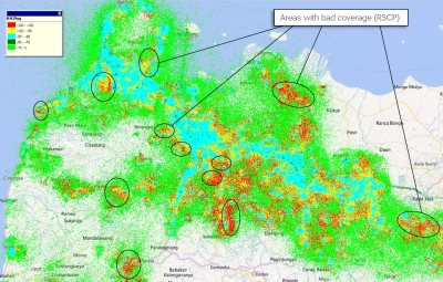
The flexible user interface allows engineers to view maps and tables showing RF KPIs such as signal strength and interference, based on actual measurements geolocated to building level accuracy. These maps and tables can be analyzed and filtered to identify problem areas such as areas of high drop call rates. Individual calls can be selected and complete Layer 3 detail viewed to establish root cause.
The automated problem detection functionality rapidly guides engineers to areas of the network that do not meet defined KPI thresholds.
Sophisticated automated optimization features automatically solve challenges such as recommending changes to neighbour relationships, identify scrambling code and frequency clashes and propose resolutions. Dedicated reports identify coverage overshoots and guide engineers to the correct antenna tilt adjustment.
Ceрвисы
White Papers и книги
Практические кейсы
Похожие продукты
Поддержка на каждом этапе работы
Мы оказываем техническую поддержку, предоставляем услуги, программы обучения и все необходимые материалы. Наша деятельность направлена на максимальное повышение отдачи от ваших капиталовложений в систему VIAVI.
Позвольте вам помочь
Мы всегда готовы оказать вам всю необходимую помощь.
