Симуляция GPS

Проверка характеристик GPS-приемника с помощью передовых технологий тестирования VIAVI.

Многоканальная система тестирования GPS обеспечивает трехмерную симуляцию, которая позволяет выбирать любой набор видимых космических летательных аппаратов.

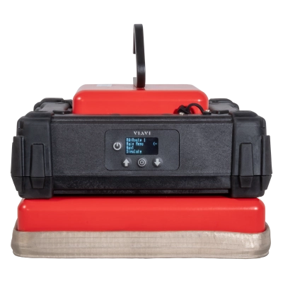
VIAVI has leveraged decades of industry experience to deliver comprehensive and affordable test, validation, and maintenance solutions for GPS/Galileo-enabled devices. The versatility of the GPSG-1000 portable satellite simulator brings precision and convenience to test processes ranging from aerospace and avionics maintenance to consumer devices and application development.

Industry-leading features include simultaneous 12-channel simulation across multiple global GNSS/SBAS standards and dynamic 3D position simulation with multi-leg waypoint entry schemes to recreate aircraft flight characteristics. Advanced record and replay capabilities bring live GNSS signals to the lab to facilitate real-world prototype testing.

ПРОДУКТЫ

GPSG 1000

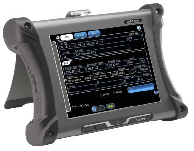
Портативный имитатор позиций спутников GPSG-1000

Развитые функции тестирования оптимально подходят для проверки работоспособности устройств с поддержкой GPS
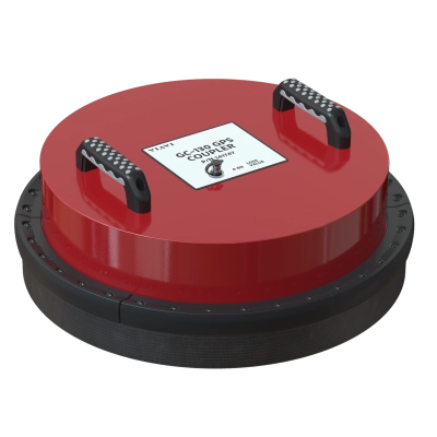
GC-130 GPS Antenna Coupler Kit

GC-130 GPS Antenna Coupler Kit

Solves the problem of poor GPS coverage in hangar environments or when a simulated static or dynamic GPS signal is required

What is a GPS Signal Simulator?

A GPS Signal Simulator generates geolocating RF signals for the purpose of testing GPS-enabled devices (receivers). With GPS capabilities now standard in avionics, wireless network timing devices, and many other government and commercial applications, the GPS simulator has become an essential tool for expediting pre and post-deployment performance testing. 

  • A GPS signal simulator produces data streams that replicate the data transmitted by real GPS satellites, enabling receiver functionality to be fully validated in the lab. 
  • Multi-channel generators are used to simulate several GPS and/or other global navigation satellite system (GNSS) transmissions simultaneously.
  • Geolocation is now ubiquitous for many transportation and E-commerce applications. Mapping application developers use a GPS route simulator to ensure real-world performance and reliability.

A GPS satellite simulator provides flexibility and convenience as compared to over-the-air or “live sky” testing by allowing conditions and parameters to be dynamically recreated.

How Does a GPS Signal Simulator Work? 

To understand the function of a Global Positioning System (GPS) simulator, it is useful to review the basic operating principles behind the GPS technology that originated in the late 1970s as part of the joint civilian/defense program known as NAVSTAR

  • A Constellation of 32 synchronized satellites or “space vehicles” (SVs) continually orbit the Earth at an altitude of approximately 12,550 miles. 24 of the satellites are required for operation while the other 8 are reserved for maintenance and redundancy.
  • GPS Satellites are spaced in six orbital planes such that 4-6 are visible from any location on Earth at any given time. Data from at least 4 visible sources is needed to produce an accurate “fix”.
  • Atomic clocks onboard each satellite provide precise time stamps which are transmitted towards the ground along with positional data. 
  • Signals from closer satellites will arrive faster, which allows trilateration algorithms to pinpoint the receiver location based on an analysis of all incoming signals.
  • Receivers collecting and deciphering GPS data are found within cell phones and dedicated ground control stations, along with aircraft, ships at sea, and land vehicles in motion.

Timing and Synchronization - GPS Signal Quality

 
A GNSS or GPS signal simulator generates data-carrying RF signals identical to those produced by satellites. Output parameters are quickly adapted to enhance and accelerate the test process.

  • To meet the minimum threshold for trilateration, the GPS position simulator must be capable of generating at least 4 discreet signals, although a channel capacity of 6-12 is preferable.
  • Strategically introduced “scenarios” presented to the receiver-under-test are used to assess signal acquisition, data retention, and overall performance under a variety of potential real-world GPS conditions.
  • While a GPS constellation simulator typically generates all satellite signals from scratch, record and playback features can also be used to capture RF signals from live satellite constellations and replay them on demand.

What is the Frequency of a GPS Signal?  

GPS operates over three discrete L-band (1-2 GHz) frequencies. The addition of new frequency bands over time has led to faster and more precise positioning. Each of these bands has unique properties that can be replicated by a high-end GPS or GNSS simulator.

  • L1 Band: Operating at 1575.42 MHz with 15.345 MHz of bandwidth, the L1 signal includes a coarse acquisition (C/A) code for public use and a precision code (P-code) reserved for military use. Transmitted data includes time, date, satellite status, and ephemeris (position) information. As the oldest signal type, L1 can be accessed by almost any GPS receiver, although transmission speed is relatively slow.
  • L2 Band: These signals are transmitted at a frequency of 1227.60 MHz with a bandwidth of 11 MHz. L2 signals navigate obstacles like trees, buildings, and cloud cover more effectively than L1. When used in tandem, L1 and L2 signals produce reliable and accurate information using a method known as precise point positioning (PPP).
  • L5 Band: The newest signal type operates at 1176.45 MHz with 12.5 MHz of bandwidth. As an element of the GPS III modernization program, L5 features a higher power level and enhanced signal architecture designed for safety-of-life transportation and aviation applications.

GPS Signal Simulator

  • Upgraded satellite constellations are being deployed to broadcast new and improved versions of the original L1 and L2 band signals. The modernized L1C signal promotes interoperability between civilian GPS and international GNSS systems and improves reception. 
  • L2C signals transmitted at a frequency of 1227.6 MHz use ionospheric correction to boost accuracy. The industry-leading VIAVI GPSG-1000 portable GPS/GNSS satellite simulator facilitates multi-channel test scenarios with any combination of legacy and modernized signal types. 

How to Simulate a GPS Signal  

A GPS signal simulator mimics the radio frequency (RF) operation of a GPS satellite. Digital modulation techniques are used to multiply, mix, and combine the output of a central 10.23 MHz master clock in stages to simulate a space vehicle (SV) broadcast.

  • A GPS satellite constellation simulator configures key variables into pre-programmed or customized test scenarios without ever leaving the test bench. This includes the quantity and position of satellites, power levels, transmission band(s), constellation health, and almanac data.
  • A GPS walking simulator is established by adapting signal transit times along with refection and interference settings to simulate a receiver in motion. The trajectory of incoming signals can also be adjusted to approximate SV orbits. 
  • GPS record and replay capabilities capture output from live satellite antennas at a high rate of speed. These functions combine the authenticity of actual satellite signals with the flexibility of on-demand testing.

Is There a Difference Between GNSS and GPS Signal Simulators?

Any navigation system based on signals produced by satellites in orbit is included in the broader definition of a global navigation satellite system (GNSS). This includes the GPS system owned and operated by the United States along with a growing number of international satellite navigation systems. A GNSS constellation simulator is capable of producing test signals based on GPS technology along with other international standards such as BeiDou (BDS), Galileo, GLONASS, IRNSS and QZSS. 

  • BeiDou: The BeiDou system, also known as BDS, was commissioned by the People’s Republic of China in 2020. This fully operational and global network encompasses 35 satellites.
  • GLONASS: The Global Navigation Satellite System (GLONASS) was established by the Russian Federation and first went live in 1995. This system consists of 24+ satellites orbiting 11,890 miles from Earth. 

Global National Satellite System

  • Galileo: The first GNSS system owned and operated by the European Union (EU) began initial service in 2016. The complete network of 30 satellites (24 operational, 6 spare) was fully commissioned in 2021. High-precision service produces accuracy within ± 1 meters for civilian applications. Galileo is interoperable with both GPS and GLONASS.
    VIAVI GPSG-1000 Galileo simulator capabilities are inclusive of the E1, E5, E5a, and E5b Galileo frequency bands.

GPS-1000 Screen

Key Features of a GPS Signal Simulator

As the number of GNSS constellations grows along with the number of applications for GPS receivers, the features available in an advanced GPS or GNSS constellation simulator have also expanded. These capabilities combine to produce more realistic and flexible scenarios and quantifiable time savings. 

  • Multi-SV Simulation: Although the simulation of 6 SVs provides an adequate representation of an orbital plane for testing and validation, the flexible 12-channel configuration of the VIAVI GPSG-1000 GNSS simulator is critical for emulating multiple scenarios (e.g., GPS and Galileo interoperability) simultaneously. 
  • SBAS Simulation: Satellite based augmentation systems (SBAS) utilize geostationary satellites to enhance the accuracy and integrity of GNSS for critical operations such as plane landings. High-end feature sets include SBAS simulation capabilities for the U.S. Wide Area Augmentation System (WAAS) and European Geostationary Navigation Overlay Service (EGNOS). 
  • Almanac Information: GPS almanac data transmitted every 12.5 minutes includes course orbital information for all satellites in the constellation, while the ephemeris data captures the precise location of each individual SV. Including this data in the simulation creates a more accurate facsimile of real-world performance.  
  • Remote Operation: For a GPS signal simulator, workspace boundaries can encompass expansive avionics maintenance and installation facilities or EMI-sensitive electronics test labs. Remote control operation can improve test efficiency, reliability, and repeatability.

VIAVI GPS Signal Simulators

VIAVI has established a new benchmark for GPS simulator performance. As modernized GPS bands are adopted and interoperability improves between GNSS standards, software upgradable GPS signal simulators from VIAVI seamlessly support current and emerging test and validation requirements. 

  • GPSG-1000 Portable Satellite Simulator: Standard features include simultaneous GPS and Galileo simulation with up to 12 SVs. One or two channels may be allocated to EGNOS or WAAS satellite-based augmentation simulation. An unlimited number of navigation plans, utilizing 3D waypoints to define a route, can be programmed, and recalled. Record and playback features support live simulation options while RAIM testing is used to verify safety-critical GPS receiver function. 
  • GC-130 GPS Antenna Coupler Kit: Designed for use with the GPSG-1000 in aircraft hangars and other low coverage areas, the optional GC-130 coupler mounts over the aircraft’s GPS antenna to provide >20 dB of isolation. This ensures outside GPS signals are not seen by the aircraft’s GPS receiver. 

GPSG 1000

VIAVI GPS Signal Simulator Applications

With GPS capabilities now standard in a wide variety of consumer, industrial, and transportation products and devices, the applications for GPS simulation continue to multiply. The GPSG-1000 can verify the sensitivity of GPS receivers for avionics systems as well as many ground-based transportation and personal device applications. 

  • Avionics: The GPSG-1000 supports advanced avionics testing with simulated 3D positioning to recreate routes and flight conditions along with satellite movement and visibility. Complete ADS-B transponder performance testing is completed with the correct number and quality of GPS signals simulated for receiver lock. Flight conditions for LPV approaches can also be emulated. 

  • Transportation and Agriculture: New advanced-driver assistance systems (ADAS) and GPS-based precision agriculture methods accelerate the demand for accurate ground-based GPS receivers. This highlights the importance of GPS simulator versatility and field portability to ensure both safety and functionality are maintained.  

  • Mapping and Surveying: GPS technology has improved mapping and surveying operations by eliminating the line-of-sight visibility and distance constraints of traditional practices. Portable GPS mapping devices operating over the L1 and L2 bands can be verified quickly using customizable GPSG-1000 workflows.   

  • Handheld Devices: GPS receivers are found in all cellular phones and many other handheld devices. Dynamic simulations that include the route, speed, and SV signal trajectory are useful for validating new GPS-enabled consumer devices and mapping applications in the lab.  

Поддержка на каждом этапе работы

Мы оказываем техническую поддержку, предоставляем услуги, программы обучения и все необходимые материалы. Наша деятельность направлена на максимальное повышение отдачи от ваших капиталовложений в систему VIAVI.

Наши услуги являются эффективным дополнением к системе VIAVI и другим приборам. Они входят в общую стоимость владения

Служба поддержки позволяет возврат некачественного или неисправного оборудования производителю для ремонта или калибровки

Решения для технического обучения, обучение использованию нашей продукции, смешанное обучение для техников, работающих с новыми или существующими изделиями

Центр технической поддержки оказывает помощь в эксплуатации и настройке изделий, а также в решении возникающих проблем

Спросите у специалиста

Обращайтесь к нам для получения дополнительной информации и ценовых предложений. У нас есть специалисты, готовые дать правильный ответ на любой ваш вопрос.